Need help finding something?
FAQs
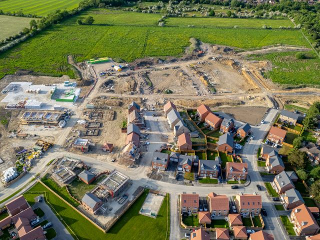
Development & Consent
What is an Arterial Watercourse?
Internal Drainage Boards (IDBs) often carry out their drainage/water level management responsibilities through the designation of ordinary watercourses as ‘Arterial Watercourses’, also frequently known as ‘Main Drains’, or ‘Adopted Watercourses’. These watercourses are (for the time being) under the control of the Board.
The status of ‘Arterial Watercourse’ is an acknowledgement by the IDB that the watercourse is of arterial importance to the Internal Drainage District (IDD) and normally will receive maintenance from the IDB. This maintenance is not necessarily carried out on an annual basis but on a recurrence deemed necessary to meet water level management requirements. The designations are made under permissive powers and there is no obligation for IDBs to fulfil any formal maintenance requirement and there is no change in the ownership or liability associated with the watercourse. Arterial watercourses are protected to a greater extent by the Board’s Byelaws.
What is a Main River?
In England, some watercourses are designated as “Main Rivers”. All other watercourses are “Ordinary Watercourses”. The Environment Agency has permissive powers to regulate and work on Main Rivers, and an IDB does not have powers to do works on these watercourses, unless they are doing work on behalf of the Environment Agency. The Statutory Main River Map is available for viewing via the government web pages.
When do works require the Board’s Consent?
The most common types of work which require the Board’s Consent (Land Drainage Consent) are listed below.
- Works near to (typically within 9m of) an arterial watercourse
- Works that introduce additional water to a watercourse, such as a new outfall from an impermeable area.
- Works that alter a watercourse or water control structure (such as a new access culvert).
- More information can be found on our “Land Drainage Consents” page
How can I apply for Land Drainage Consent from the Board?
The forms and guidance are available here
Where are the policies relating to Land Drainage Consents?
Applications for Land Drainage Consent will be considered in accordance with the policies listed on the ‘Apply for land drainage consent‘ page
Why do the WMA Member Boards comment on Planning Applications?
By engaging with the planning process the WMA Member Boards are seeking to:
- Reduce flood risk to communities within its Internal Drainage District and highland catchment.
- Promote sustainable development in sustainable locations by supporting sound planning decisions that can be implemented by applicants and developers.
- Reduce the potential for conflict between the planning process and the IDB regulatory process.
- Develop an understanding within other authorities and third parties of the flood risk and capacity issues within IDB areas so they can be considered through the planning process.
- Make a contribution towards the achievement of Sustainable Development, as per Section 27 of the Flood and Water Management Act 2010.
Which planning applications does the WMA comment on?
With the aim of promoting sustainable development, each WMA Member Board will aim to review and comment on applications which may increase flood risk within the Board’s Internal Drainage District (IDD) in one or more of the following ways:
- The site is adjacent to an Adopted Watercourse
- Works may be proposed to alter any Ordinary Watercourse
- The proposals may result in the displacement of flood water
- The proposals may introduce water to the IDD
- The area is known to suffer from poor drainage
Can an IDB ‘veto’ a Planning Application?
No, a WMA Member Board can object to a planning application, but it is the Local Planning Authority’s responsibility to ensure applications do not increase flood risk on site of elsewhere as per paragraph 163 of the National Planning Policy Framework, they may do this under advice from the Lead Local Flood Authority and the relevant Internal Drainage Board.
The Board’s regulatory process is set out under the Land Drainage Act 1991 and is separate to the planning process, however the ability to implement a planning permission may be dependent on the granting of the Board’s Consents.
As both regulatory regimes should consider the impact of the works on flood risk, it is unlikely that a site should gain 1 form of consent but not the other. However, if a site does receive only 1 of the required consents (e.g. the site received planning consent but not the Board’s consent), an appeal may be heard by either the Secretary of State or the President of the Institution of Civil Engineers (depending on the circumstance) to determine if either consent was granted or withheld unreasonably.
My application for consent has been refused. What is my Right of Appeal?
If you believe the Board has withheld consent unreasonably then the Land Drainage Act 1991 allows you a right of appeal to an independent arbitrator. Before making a formal appeal the Board offers an appellant a right of reply to the Board. This right of reply should take the form of a written statement setting out why the application should be considered favourably. The matter will then be taken to the next Board meeting for further consideration.
I am looking to buy a property but there is a large watercourse (dyke/ditch/drain) next to it. Would I become responsible for maintaining this watercourse?
A ‘riparian owner’ is a person who owns the land or property adjacent to a watercourse. Whilst some Drainage Boards own certain watercourses, most are riparian or privately-owned. The Law of Property Act 1925 (Section 62) remains in force, stating that ‘a conveyance of land shall be deemed to include and shall by virtue of this Act operate to convey with the land all buildings, hedges, ditches, fences, ways, waters, watercourses, liberties, easements, rights and advantages whatsoever appertaining or reputed to appertain to the land or any part thereof’. This means that drainage will be transferred from a vendor to a purchaser. Check the property Deeds for any possible exclusions which may apply to the landholding.
I wish to sell my property but I’ve been told that there is a ‘restriction’ in favour of the Board on the property title register. What does this mean?
Most likely there is a Board Arterial Watercourse (‘Main Drain’ or ‘Adopted Watercourse’) under the control of the Board either next to or crossing the property. Where the development warrants a formal legal agreement to protect the Board’s access requirements, the Board may enter into a ‘Deed of Indemnity’ with the registered land owner. This legal agreement could relate to a pre-existing structure such as a building or fencing within the Byelaw distance, an outfall pipe and headwall for surface water discharge or a package treatment plant outfall pipe directed into an Arterial Watercourse. When the property is sold on, the original restriction (if still applicable) is conveyed with the title by a ‘Deed of Covenant’ and a Certificate will be issued by the Board to enable the legal transfer. Your conveyancing solicitor will help you with this process. The Board’s officers are likely to request an inspection of the property before the Board will issue the Certificate of compliance. If there has been any additional development outside the terms of the original Deed schedule then your property sale could be delayed until the additional items are removed or another consent is issued by the Board for the additional items (if these items meet with the Board’s prevailing development control policies). When additional development cannot be determined through the consenting process by officers under delegated authority, then a report will be taken to the next available Board meeting for a committee decision.
How much does an application cost?
Application fees are detailed in the Development Control Charges and Fees Policy Document.
How long will it take to determine my application?
Once the application fee is paid, and all relevant information is supplied, we aim to issue consent within 8 weeks. If you have any deadlines which the case officer should be aware of please let them know and they will try to help you meet your deadlines if possible.
How to I know what catchment my proposal is within?
You can find this on the ‘Mapping’ page for the relevant IDB.
What if I don’t know the grid reference for my proposals?
You can use https://gridreferencefinder.com/ to find the location information for a given area.
What is a Deed of Indemnity?
A Deed of Indemnity is a legal agreement whereby the owners of a property want to develop or do something on their property that affects the Internal Drainage Board’s adjoining ownership or statutory interests which are protected by Byelaws. It is a legally binding agreement on the owner of the adjoining property and will transfer on sale to the new owner of that property to protect the Board’s adjoining ownership or Byelaws.
Such an example might be that works will be carried out and/or planting take place within 9 metres of the edge of a Board arterial watercourse and conditional consent is required from the Board under its Byelaws. The property owner will bind itself in accordance with the Deed and this will be noted as a restriction on the property title. You are recommended to take legal advice before entering into a Deed of Indemnity.
Deeds of Indemnity are subject to an administration fee (see the Board’s Development Control Charges and Fees document) plus the standard fee charged by Land Registry for lodging the document with them (see Land Registry website). Where a Deed is more complex than usual then the administration fee will be increased to reflect the additional costs to the Board.
On the sale of your property a Deed of Covenant will be entered into between the Board and the Purchaser. Your Solicitor will deal with the Deed of Covenant. Fees are payable to the Board to complete this process (see link above).
What is a Development Contribution?
A Development Contribution is a one-off charge placed on a development by an Internal Drainage Board (IDB). The Development Contribution, net of its collection cost, is intended to reflect and contribute towards the actual or potential cost of work required to be undertaken by the IDB at some stage to manage the additional run-off resulting from the discharge of surface water from new impermeable areas into the Board’s District.
The works described above can include maintenance activities, the operation of structures or the physical improvements of the Board’s drainage/flood risk management infrastructure. It can also include the surveying, monitoring and modelling of infrastructure capacity.
It should be noted that the Development Contribution does not involve any profit-making for the relevant IDB. Indeed, the likelihood is that the sums paid amount to no more than a part-contribution to eventual works undertaken.
When is a Development Contribution incurred?
A Development Contribution is a payable when the Board issues consent for the discharge of surface water to the Drainage District. The payment is required as a condition of the consent.
The aforementioned consent is required as per Byelaw 3 of each Board’s Byelaws, and as per Byelaw 28(c), any consent granted can be subject to conditions as the Board may consider appropriate.
Why is a Development Contribution incurred?
Introducing impermeable areas to greenfield sites generally increases the volume of surface water runoff downstream. Even when peak runoff rates have been limited to less than greenfield rates, the actual volume would have been increased. As such, even where attenuated, the discharge will still represent an increase from the agricultural discharge rate and more particularly increase the volume of water discharged into an Internal Drainage District.
Where this is the case, the Board can apply a Development Contribution as a condition of consent.
By way of an example, increases in the volume of water discharged into pumped catchments could require the relevant Board to operate its pumping stations for longer to maintain the same water levels as prior to development. Alternatively, if the capacity of the station is limited this may require the widening of drains and/or the creation of new off-line storage to ensure the volume of water can be accommodated at the pump.
How can an Internal Drainage Board charge a Development Contribution?
In line with the provision of Byelaw 28(c) in the relevant WMA Member Board’s adopted Byelaws, any consent granted may be either unconditional or subject to such conditions as the Board may consider appropriate. One of the conditions imposed as part of surface water discharge consent approval is the payment of a Development Contribution to the Board.
Isn’t the Board already funded to manage the discharge from my development?
Whilst Internal Drainage Board’s receive funding from other sources it should be noted that these are specifically designed and calculated to cover the costs incurred by mitigating the effects on the Drainage District from the current built and agricultural environment. They are not aimed at reflecting the additional burdens placed on the Board by the creation of additional impermeable areas positively discharged directly or indirectly to our area.
Has the planning process already secured the funding for drainage through Section 106 of the Town and County Planning Act 1990?
No, the consenting process under the Land Drainage Act 1991 and the relevant Board’s adopted Byelaws is separate to the process of obtaining planning permission. (Much in the same way as any separate agreements/consents required from organisations such as the Highway Authority and utility providers).
Has the planning process already secured the funding for drainage through a Community Infrastructure Levy?
No, a Community Infrastructure Levy (introduced by the Planning Act 2008) is a charge levied by some Local Planning Authorities to help them deliver infrastructure needed to support development in their area. Local Planning Authorities (such as District Councils) then use the Levy that has been collected to fund a wide range of infrastructure as defined by section 216(2) of the Planning Act 2008. Drainage and water level management infrastructure are not included within Section 216(2) of the Planning Act 2008, and Internal Drainage Boards do not receive any part of this funding.
How is the Development Contribution calculated?
The methodology used to calculate a development contribution is contained and explained within the Board’s Development Control Charges and Fees document
What happens if I do not wish to pay the Development Contribution?
If a developer does not want to pay the contribution, all runoff from the development would have to be stored on the development site with no outfall into the ordinary watercourse or any drainage system which will convey the water to the Board’s District. Alternatively, where developers are confident that their drainage design reduces the rate and volume of surface water downstream, they should provide evidence of this in the form of flow hydrographs at the location of each discharge point for the pre- and post-development scenarios. These should demonstrate that there is no change to the areas under the graph (volume) between the pre and post development scenarios.
When should I apply for consent?
We strongly recommend that applications apply for consent to confirm the viability of the proposals prior to the determination of a planning application. A viable strategy at the outline stage enables both the applicant and the Local Planning Authority (LPA) to proceed with increased confidence in the site’s ability to drain (and thereby prevent flooding – a material planning consideration) and the ability to implement the outline permission, if granted. Prior to engagement with the consenting process, no assurance can be provided by the Board that the wider drainage network has sufficient capacity to accept the proposed positive discharge connection.
When do I receive / pay the Development Contribution invoice?
The Surface Water Development Contribution (SWDC) or Treated Foul Water Development Contribution (TFWDC) is payable upon the granting of consent, however we acknowledge that developers may want an assurance that the proposals are acceptable in principle, prior to progressing to formal consent and paying the development contribution, resultantly we utilise the two stage consent process outlined in table 1 overleaf.
I’ve received a letter from the Board about a contravention of the Land Drainage Act 1991 and/or Board Byelaws. What should I do?
Please do not ignore this letter. It means that officers have identified a contravention (legal offence) within or next to land which we believe is under your ownership. The aim of the warning letter is to raise awareness about your responsibilities and liabilities in law. The letter will provide details about the offence and steps you must follow to remedy (make good) the contravention. Please contact our team as soon as possible and within the time limit given in the letter. If helpful, an officer can visit to discuss the matter with you during our standard working hours.
My neighbour is filling-in a watercourse/ditch/dyke. Are they allowed to do this?
The initial answer is probably no. If the property is located within the Internal Drainage District then any person must seek permission in advance from the Internal Drainage Board to alter or modify the watercourse under the terms of the Land Drainage Act 1991. This permission is known as Land Drainage Consent. Please report unusual activity and provide a location (street name, postcode or What3Words) to our planning team (telephone 01553 819630 or email planning@wlma.org.uk). All reports will be treated anonymously. The same rule about works to ordinary watercourses applies outside the Internal Drainage District boundary where the regulator for works to watercourses is likely to be the Lead Local Flood Authority.
I’ve seen pollution in a watercourse. Who should I report this to?
Pollution in watercourses should be reported to the Environment Agency in England. Further information about reporting environmental incidents is available on the government web pages at https://www.gov.uk/report-environmental-incident
I’d like to use my canoe/kayak/paddleboard on an Arterial Watercourse (Main Drain). Is this possible?
Arterial Watercourses (Main Drains) were cut to convey surplus water for the purpose of agricultural land drainage. Most Internal Drainage Boards do not have statutory powers of navigation defined by Act of Parliament, so a public (common) right of navigation does not apply. For this reason there will be no licensing system in place for users of recreational craft. We discourage paddlers from using the Board’s flood drainage infrastructure for safety reasons. Water levels and currents can change without warning as a result of pumping station operations.
Waste has been flytipped into watercourse. Who should I report this to?
Waste in watercourses can result from an accumulation of general litter, or from fly tipping (the illegal dumping of waste). The main detrimental effects of waste accumulation in watercourses are a reduction of flow in the watercourse and environmental damage.
The Board do not have enforcement powers with regard to fly tipping as these rest with the relevant Local Authority and the Environment Agency. As such, when notified of fly tipping in the Internal Drainage District the Board would consider the incident as follows:
If the incident is causing a significant obstruction to flow or is presenting an imminent risk of flooding within the Internal Drainage District the Board’s operatives will remove the waste as per the Board’s statutory functions. For this purpose the Board have a waste transfer licence to allow them to move waste. Waste can be temporarily stored in the relevant Board’s yard, where a waste exemption licence is in place, before disposing of in an appropriate manner.
If the Board’s operatives consider the fly tipping incident to be of a serious nature or to have already resulted in a severe consequence the Board will report it to the appropriate enforcement body, rather than attempting to deal with it itself, in case evidence is inadvertently lost, which could have been used to prosecute offenders.
In all other incidents the waste will be reported to the relevant Local Authority. In the case of a vehicle, the Police will also be informed as soon as possible. If the waste is causing a pollution incident then the Environment Agency will be informed at the earliest opportunity and the pollution contained.
Discharging Surface (Rain) Water
The discharge of surface water from an impermeable area requires consent in accordance with Byelaw 3. The Board will determine applications received seeking to discharge surface water in accordance with the policy below.
Applications for consent to discharge surface water run-off into any watercourse within the Board’s Internal Drainage District will be considered against the capacity of the receiving watercourse to accept the proposed surface water flows (rate and volume). To assist in determining the application, the Board may require the applicant to undertake hydraulic modelling work.
The requirement for consent to discharge surface water may be waived in writing at the officer’s discretion where the impermeable area is less than 50m2 and is an extension of an existing impermeable area with a satisfactory surface water outfall.
Policy: Discharge of Surface Water
The Board will only approve an application to discharge surface water where the watercourse can be evidenced as being connected to the wider watercourse network.
For systems serving impermeable areas greater than 0.25ha the proposed discharge rate should be no higher than 2/l/s/ha or annual average flood flow rate (QBar or QMed), whichever is higher. Exceptions may be allowable when it is evidenced that to achieve this rate would require a static flow control device (vortex flow control or fixed orifice plate) with an orifice smaller than 50mm* in diameter (or 100mm where debris control is not possible). Systems with a static flow control devices with an orifice smaller than 100mm in diameter should be designed to prevent debris entering the flow control device.
Applications may be refused if the Board’s Officers consider that the proposals may increase flood risk, cause environmental harm which cannot be mitigated, negatively impact the efficiency of local drainage or if the receiving watercourse will not be capable of accepting the planned additional flows.
If consent is granted by the Board, this may be conditional, including the payment of a Surface Water Development Contribution as outlined by the Board’s Development Control Charges and Fees Policy.
Notably it is the Board’s preference that systems are adopted by statutory authorities / bodies whenever possible.
*75mm for the Pevensey and Cuckmere WLMB
Discharging Treated Foul Water (Treated Effluent)
The discharge of treated foul water (via an appropriate treatment plant) requires consent in accordance with Byelaw 3. The Board will determine applications received seeking to discharge treated foul water in accordance with the policy below.
The Board’s consent does not replace the applicant’s obligation to seek an Environment Permit from the Environment Agency for the treatment plant and outfall or meet the general binding rules published by DEFRA.
Policy: Discharge of Treated Foul Water
The Board will only approve an application to discharge treated foul water where the watercourse can be evidenced as being connected to the wider watercourse network.
Applications may be refused if the Board’s Officers consider that the proposals may increase flood risk, cause environment harm which cannot be mitigated, negatively impact the efficiency of local drainage or if the receiving watercourse will not be capable of accepting the planned additional flows.
Where the discharge is to an open watercourse, the discharge pipe should be installed through a pre-cast concrete outfall unit dug in flush with the drain batter. Suitable erosion protection should be installed below the headwall down to the toe of the watercourse and also dug in flush with the drain batter.
Where the discharge is to a piped watercourse, the discharge pipe should be connected into an existing inspection chamber, or a new inspection chamber should be constructed to the Board’s specification to accommodate the outfall.
If consent is granted by the Board, this may be conditional.
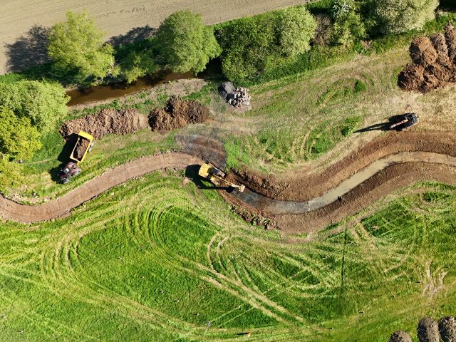
Altering a watercourse
The alteration of an ordinary watercourse requires consent in accordance Section 23 of the Land Drainage Act 1991, and Byelaws 4, 6 and 15. The Board will determine applications received seeking to alter a watercourse in accordance with the policy below.
Section 23 of the Land Drainage Act prohibits the installation or alteration of a culvert, the installation of a mill, dam, weir or similar obstruction to flow without the prior consent of the Board. Byelaw 4 further restricts the reconstruction, reduction, repair and removal of these structures, as well as the operation or alteration of bridges, headwalls and water control structures.
Furthermore, Byelaw 6 restricts the stopping up or diversion or alteration of flow / water level of a watercourse and Byelaw 15 restricts the dredging or raising of any material from the bed or bank of an arterial watercourse.
As part of any application to alter a watercourse the applicant has the responsibility to prove that the proposed works would not increase flood risk or negatively impact the efficiency of local drainage.
Policy: Watercourse Alterations
The Board will only approve an application to culvert or infill a watercourse if;
- There is no reasonably practicable alternative (including health and safety considerations).
- The proposal is for a replacement culvert or bridge.
- Any culverting is for the sole purpose of providing access (and the total length is the minimum required for the access).
- The proposal forms part of a drainage, agricultural or environmental improvement scheme.
Applications for the installation or alteration of mills, dams, weirs, flow controls, headwalls, bridges and other structures regulated by Section 23 of the Land Drainage Act 1991, and Byelaws 4/6/15 will be considered on a case by case basis.
Applications may be refused if the Board’s Officers consider that the proposals will increase flood risk or negatively impact the efficiency of local drainage, cause environmental harm that cannot be mitigated or negatively impact the ability of the Board to carry out its operations.
Undertaking works near Arterial Drainage Infrastructure
Consent is required for all works within 9* metres of the edge of arterial drainage and flood risk management infrastructure (arterial watercourses and water management structures such as pumping stations) in accordance with Byelaw 10**. The Board will determine applications received seeking to undertake works near arterial drainage infrastructure in accordance with the policy below.
Maps on the Board’s webpages clearly show which watercourses are designated as Arterial Watercourses. The 9* metre distance is measured from the edge of the drain (whether open or piped). In the case of an embanked drain this is 9* metres from the landward toe of the embankment.
Although all cases will be considered on a case by case basis, the following points represents common works and their likely acceptable distance. This list is for guidance only:
- Permanent Structures = 9m* from brink (Open Watercourse) / 9m* from outside edge (Culverted Watercourse)
- Trees = 9m* from brink (Open Watercourse) / 9m* from outside edge (Culverted Watercourse)
- Ground Surfacing = 7m* from brink (Open Watercourse) / 1m* from outside edge (Culverted Watercourse)
- Demountable Fencing = 7m* from brink (Open Watercourse) / 1m* from outside edge (Culverted Watercourse)
- Demountable Structures = 7m* from brink (Open Watercourse) / 3m* from outside edge (Culverted Watercourse)
- Hedging = 7m* from brink (Open Watercourse) / 3m* from outside edge (Culverted Watercourse)
*7 metres within the Waveney, Lower Yare and Lothingland IDD
** Byelaws 10 and 17 for Waveney, Lower Yare and Lothingland IDB
Policy: Works within 9* metres of Arterial Drainage Infrastructure
The Board will only approve applications for consent for works (including replacement works) within 9* metres of arterial drainage infrastructure (as required by Byelaw 10**) if the Board’s officers consider that the proposed works will not increase flood risk, negatively impact on the ability of the Board to carry out its operations (including but not limited to the Board’s usual way of working, current access arrangements, available resources and the risks posed to Board employees, now or in the future) or increase the liabilities of the Board. Permanent Structures (any building which is not demountable, including any extension to a previous structure) are unlikely to be approved within 9* metres of the brink of any arterial drainage infrastructure.