Need help finding something?
Benacre & Kessingland Flood Management Project
Footpath Access Update – Benacre & Kessingland Flood Risk Management Project
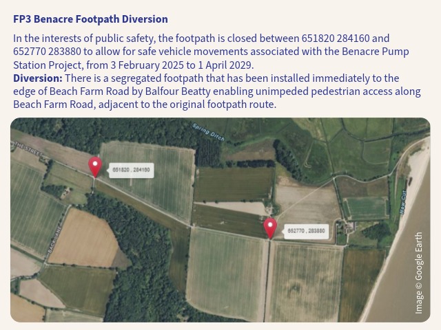
Current Footpath Access
Part of the Benacre Footpath 3 (FP3) has been closed in the interests of public safety and to allow for safe vehicle movements for the Benacre Pump Station Project.
To maintain safe public access during construction, alternative route has been provided which runs parallel to Benacre Footpath 3. This route has been installed by Balfour Beatty and provides a segregated pedestrian route immediately alongside Beach Farm Road. This provides uninterrupted pedestrian access along Beach Farm Road while allowing construction activities to continue safely.

Future Coast Path and Public Rights of Way
The future alignment of the King Charles III England Coast Path and associated Public Rights of Way is the responsibility of Natural England and Suffolk County Council.
Natural England has provided the following update regarding the future route:
“Natural England’s proposal for the King Charles III England Coast Path between Southwold and Pakefield was approved by the Secretary of State on 18 September 2025. Natural England is currently working with Suffolk County Council to establish the coast path.
Natural England and Suffolk County Council are aware of the flood risk management project underway near Kessingland, which will eventually require the creation of an intertidal channel through part of the approved coast path route. The channel is expected to be formed towards the end of the flood risk management project, which is currently anticipated to be completed in summer 2030.
Until the intertidal channel is created, the approved route remains the most appropriate alignment and will be used when the coast path opens (2025).
Once the channel has been created and the existing route is no longer viable, the coast path will ‘roll back’ to the next suitable alignment, in accordance with the methodology set out in the Coastal Access Scheme. This process requires further consultation with landowners, occupiers and others with a legal interest in the land to ensure a fair balance between public access and land management interests.
While detailed options are still being developed, there is early agreement in principle between Natural England, Suffolk County Council, The Benacre Estate and the Water Management Alliance that part of the future coast path will be aligned within the Lothingland works corridor, crossing the River Hundred at the closest practical point to the coast.
Natural England is currently focused on completing the establishment of the King Charles III England Coast Path in Suffolk. A fuller assessment of the permanent route options at Kessingland is expected to take place after coastal access rights have commenced, with Suffolk County Council leading further discussions on the final alignment.”
Although the final decision on the alignment of the King Charles III England Coast Path rests with Natural England, in consultation with the landowner, the Water Management Alliance will continue to work closely with these partners and will share further information on future access arrangements as it becomes available.
Visit our project page to find out more about the Benacre & Kessingland Flood Management Project